Published: 16:00 BST, 5 September 2026 | Updated: 16:03 BST, 5 September 2026
A hurricane has never made landfall in California, but an expert meteorologist believes the stage is set for a historic storm to threaten millions along the coast.
AccuWeather Senior Meteorologist and Long Range Forecaster Paul Pastelok told the Daily Mail there are three key ingredients needed for a cyclone to form in the Pacific and make the rare turn toward the California Coast.
First, the hurricane needs extremely warm water between Mexico and the Baja California Peninsula, the thin, 775-mile-long strip of land right below California and the US-Mexico border.
The second is a weather pattern that slides down from the Pacific Northwest into California that can pull a tropical storm north instead of letting it fade or turn out to sea.
The last ingredient is calmer upper-level winds in the eastern Pacific, which make it less likely that the hurricane gets ripped apart and more likely to keep its strength.
Pastelok warned that, thanks to the weather phenomenon El Niño warming the Pacific this summer, these ingredients are already coming together to make a severe storm not just possible, but likely during hurricane season.
Moreover, Pastelok's team has predicted that this El Niño could be one of the strongest in history and continue to affect the weather through next year.
He said: 'That water is just sitting there, boiling around the Baja. If anything does form and take a turn, it may be able to maintain itself longer than it normally does before it dissipates. And so, the intensity of the aftermath of tropical systems could be felt in parts of California this year.'
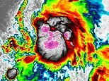
Tropical Storm Karina (Seen on radar) is one of multiple Pacific hurricanes to threaten the California Coast this summer
Multiple tropical cyclones have formed during the 2026 Pacific hurricane season. Forecasters have warned of rare impacts in the US Southwest and Hawaii
The formation of El Niño means that the Pacific Ocean has become noticeably warmer than its historical average.
However, this warming flips global weather patterns, giving storms in the Pacific more warm water to use as fuel, while weakening hurricanes in the Atlantic by making the air more turbulent.
AccuWeather meteorologists predicted that this year's El Niño will likely see surface temperatures in the Pacific Ocean rise by 4.8°F (2.66°C), which is often described as a 'Super' El Niño.
Pastelok said this first ingredient is essentially locked in place through the end of 2026, calling the increasing temperatures between Mexico and the Baja a 'marine heat wave.'