Published: 15:11 BST, 28 August 2026 | Updated: 16:22 BST, 28 August 2026
Tropical Storm Karina is now projected to strengthen into a major hurricane as more forecasting models show a potentially destructive path to California.
The National Hurricane Center (NHC) revealed that Karina, which currently has sustained winds of more than 50 mph, is expected to reach hurricane status as early as Friday night.
By Sunday morning, forecasts show the giant cyclone strengthening into a Category 3 hurricane, meaning its winds will exceed 111 mph.
New spaghetti models, which track all possible paths of tropical storms and hurricanes, show multiple routes that would take Karina straight into the California Coast, potentially impacting millions of Americans.
Early predictions from the American forecasting model, known as GFS, showed several possibilities for a historic landfall in San Diego or Los Angeles.
The so-called European model, also known as the EPS Ensemble, was more skeptical of a US landfall on Thursday, predicting that Karina would stay away from the California Coast and move out to sea.
However, both prediction models were updated on Friday, with both now showing potential paths to Southern California and points further north.
A hurricane has never made landfall in California in recorded history, according to the National Weather Service, and the last time a tropical storm directly impacted the state was in 1997.
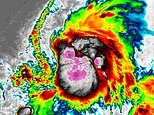
Tropical Storm Karina (Seen on radar) is expected to become a major hurricane by Sunday, August 30
Beachgoers in San Diego (Pictured) may see the first tropical storm or hurricane near Southern California in nearly 30 years next week (Stock Image)
Forecasts predict Karina will reach hurricane status by Friday night
A tropical storm has not taken such a path, from the Pacific Ocean straight into the California Coast, in nearly a century, when the Long Beach Tropical Storm landed in 1939.
It is important to note that forecast models can shift dramatically once storms form and get closer to making landfall. The farther into the future a forecast model tries to predict, the weaker the certainty of it being correct gets.
Spaghetti models, which show a large sampling of weather predictions, also reveal a great amount of uncertainty about a hurricane when they show paths going in several different directions – which is the current case with Karina.