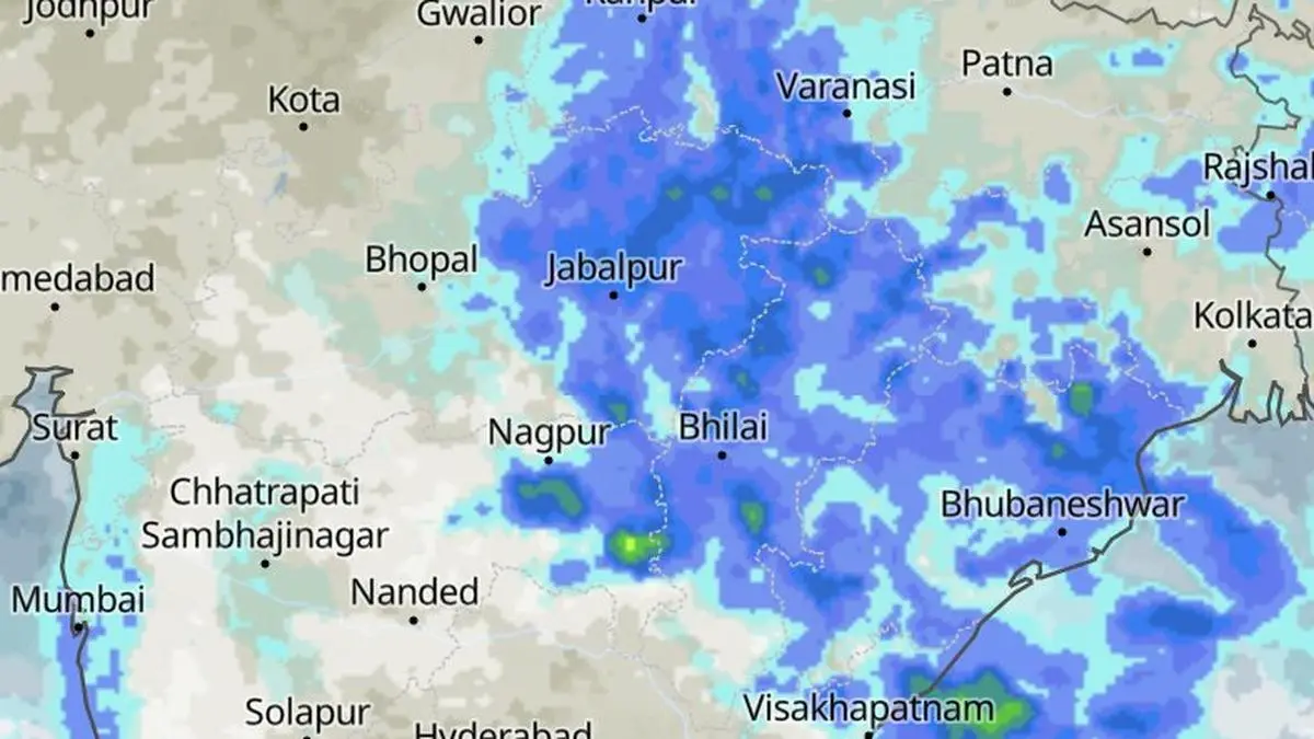
Satellite pictures on Saturday evening revealed a tapestry of rain and clouds draped across from the Bay of Bengal into East-Central and North-West India on eve of a fresh ‘low’ taking shape over the Bay.
| Photo Credit:
www.meteoblue.com
The monsoon is showing little inclination to loosen its grip on the country’s eastern and central belts, with India Meteorological Department (IMD) extending a watch for a fresh low-pressure area that could take shape as early as Sunday over the waters off the West Bengal–Bangladesh coasts.
This is even as rainfall figures for August, normally the second rainiest month, until Friday have been on the lower side, under the larger El Nino impact. The country as a whole has run up a rain deficit of 15.2 per cent, with South Peninsula logging the worst at 23.1 per cent, followed by Central India (16.5 per cent); East and North-East India (13.5 per cent); and North-West India (9.7 per cent). Overall figures for the season as a whole (June to August) are not inspiring either, with all-India deficit inching up to 13.2 per cent.
The new ‘low’ comes even as its predecessor continued to linger over north-east Madhya Pradesh on Saturday afternoon. Far from being a one-day affair, the Bay’s weather pulse is expected to keep beating through the coming week and possibly right up to the end of August, numerical weather models suggest.
The Bay is, in effect, catching the rhythm of neighbouring South China Sea/West Pacific, where a succession of tropical systems has been spinning up. The resulting easterly waves are sweeping westward through the familiar Indochina corridor across Vietnam, Thailand and Myanmar before spilling into the Bay, where they reorganise into low-pressure systems.
Satellite imagery on Saturday morning showed a cluster of cyclonic circulations scattered across and around the Bay, providing several potential seeds for the next weather system. By afternoon, circulations over the west-central and adjoining north-west Bay and the north Andhra Pradesh–south Odisha coasts merged with another over the north Bay and adjoining Bangladesh.
Two other circulations one over south West Bengal and adjoining Jharkhand and another over south-west Madhya Pradesh had meanwhile weakened and disappeared. The monsoon trough stretched from Amritsar through Najibabad, Hardoi and the centre of the existing low over north-east Madhya Pradesh, then across Jamshedpur and Digha before dipping into the north-east Bay.
The emerging low’s projected track points to a fresh spell of rain over East and Northeast India, with spillover benefits for parts of North-West and Central India. Some pockets of the southern peninsula could also get a share of the bounty. The immediate past day’s rain tally already tells the story. In the 24 hours ending Saturday morning, heavy to very heavy rain lashed parts of Arunachal Pradesh, Nagaland, Manipur, Mizoram and Tripura, besides East and West Uttar Pradesh and East Madhya Pradesh.
Heavy rain was also recorded at a few places over the Andaman and Nicobar Islands and at isolated locations in Assam and Meghalaya, Odisha, Haryana-Chandigarh-Delhi, Himachal Pradesh and West Madhya Pradesh. South Interior Karnataka stood out as an outlier gainer in the southern peninsula.
The weekend and the opening days of next week are likely to maintain the familiar monsoon choreography, with East and Northeast India remaining in the rain zone, alongside parts of North-West India, the west coast and pockets of the southern peninsula. With another low potentially taking shape, the weather department has also sounded a fishermen’s alert for both the Arabian Sea and the Bay of Bengal over the next few days.
Copyright© 2026, THG PUBLISHING PVT LTD. or its affiliated companies. All rights reserved.
Comments have to be in English, and in full sentences. They cannot be abusive or personal. Please abide by our community guidelines for posting your comments.
We have migrated to a new commenting platform. If you are already a registered user of TheHindu Businessline and logged in, you may continue to engage with our articles. If you do not have an account please register and login to post comments. Users can access their older comments by logging into their accounts on Vuukle.
Source: Read the original article on www.thehindubusinessline.com