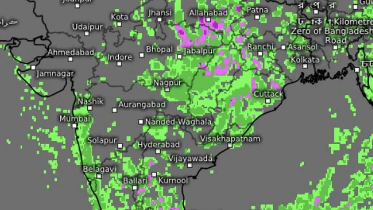
Satellite map on Wednesday showed scattered rain over North-West and East India as well as the South Peninsula as a stubborn depression fired away over Jharkhand sustaining the monsoon.
| Photo Credit:
www.meteologix.com/in
A depression that was expected to fade over north Jharkhand refused to play by the script on Wednesday, holding its ground fro overnight on Tuesday and keeping a well-stocked monsoon pipeline flowing across large swathes of northern, eastern and north-eastern India. Evening satellite maps showed thunderstorms blooming over coastal and interior Tamil Nadu, which is usual during an otherwise weak phase of the monsoon.
The depression, positioned over north Jharkhand and adjoining south-west Bihar and south-east Uttar Pradesh, was being sustained by its proximity to a resourceful monsoon trough and secondary troughs. Together, they continued to funnel moisture into the system, fuelling rain mainly over the Himalayan foothills and adjoining plains of north-west India, besides east and northeast India. But India Meteorological Department (IMD) confirmed that it has weakened into a well-marked low-pressure area by Wednesday evening.
India Meteorological Department (IMD) placed the well-marked ‘low’ about 30 km north-northwest of Daltonganj in Jharkhand. It was also 90 km east-southeast of Churk and 70 km southeast of Varanasi in Uttar Pradesh; 140 km north-northeast of Ambikapur in Chhattisgarh; and 210 km east of Sidhi in Madhya Pradesh.
The stubborn system ruled the roost against the backdrop of a fresh seasonal signal from the APEC Climate Centre in Busan, South Korea, which has projected enhanced probability of below-normal rainfall over India during September-November. The current depression, and its likely successor over the Bay of Bengal, may therefore offer only limited relief from the broader seasonal outlook.
For the South Peninsula, this could translate into normal to below-normal rainfall during the first half of the north-east monsoon in October-November. The APEC outlook, however, points to above-normal rainfall over Central India during December-February 2027, while indicating neither a surplus nor deficit signal for the South Peninsula during the latter half of the north-east monsoon.
In the near term, the depression is set to keep the monsoon active along the Himalayan foothills and adjoining plains, with widespread rain-bearing systems continuing to sweep across several regions. Isolated heavy rain is expected over Himachal Pradesh and Jammu-Kashmir-Ladakh on Thursday and Friday; East Uttar Pradesh from Thursday for three days; Uttarakhand for six days; and West Uttar Pradesh on Thursday.
The rain belt will also spill into Central India. West Madhya Pradesh is likely to receive isolated heavy rain for two days, with another spell possible on Sunday and Monday, while East Madhya Pradesh could see heavy rain for three days from Sunday. Very heavy rain is likely over East Madhya Pradesh for three days from Thursday, West Madhya Pradesh on Saturday, and Chhattisgarh on Thursday and Friday.
In the northeast, Arunachal Pradesh and Assam-Meghalaya could receive isolated heavy rain for six days from Thursday, while Nagaland, Manipur, Mizoram and Tripura are in line for five days of similar weather. East India, too, remains firmly in the rain belt. The hills of West Bengal and Sikkim are likely to get isolated heavy rain over the next two days and again on Monday and Tuesday. West Bengal may see heavy rain on Sunday and Monday, Bihar on Friday and Saturday, and Odisha for five days from Friday.
Further west, fairly widespread to widespread rain is expected over Konkan and Goa for six days from Thursday, with Madhya Maharashtra and Marathwada likely to receive rain on Thursday. For now, the depression’s unexpected staying power has ensured that the monsoon keeps drawing from a deep reservoir of moisture, turning what was expected to be a fading system into a sustained rain-maker across east and north-east India.
Copyright© 2026, THG PUBLISHING PVT LTD. or its affiliated companies. All rights reserved.
Comments have to be in English, and in full sentences. They cannot be abusive or personal. Please abide by our community guidelines for posting your comments.
We have migrated to a new commenting platform. If you are already a registered user of TheHindu Businessline and logged in, you may continue to engage with our articles. If you do not have an account please register and login to post comments. Users can access their older comments by logging into their accounts on Vuukle.
Source: Read the original article on www.thehindubusinessline.com